Community Corner
Hurricane Watches Upgraded to Warnings
Communities begin to evacuate coastal areas as flooding concerns grow.


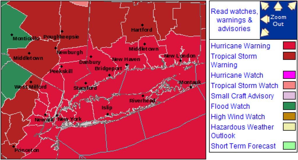


The National Hurricane Center has posted hurricane warnings for the southern counties of Connecticut and Putnam, Westchester and Rockland counties in New York, including points south into New York City and Long Island.
Northern counties of Connecticut are now under a tropical storm warning.
Hurricane warnings are issued when hurricane conditions (winds in excess of 74 mph) are expected within the next 36 hours.
Currently, as of 8 p.m. on Friday, Aug. 26, Irene remains a Category 2 hurricane with maximum sustained winds of 100 miles per hour.
Find out what's happening in Ryewith free, real-time updates from Patch.
Folks along the immediate shoreline may have to deal with potentially dangerous coastal flooding. Estimated storm surge for the Long Island Sound is around 3 to 6 feet. In addition, a new moon on Sunday will lead to abnormally high tides. Rainful up to 10 inches only exacerbates the potential danger of the situation.
What is crucial, though, is the timing of the high tides on Sunday in relation to the peak intensity of the maximum storm surge. The worst case scenario would be to have high tide coincide with maximum storm surge. This is not the case.
Find out what's happening in Ryewith free, real-time updates from Patch.
Tides are ranging from 10 a.m. in eastern Connecticut to noon in extreme western Long Island Sound, with maximum storm surge estimated to be during the mid-afternoon hours.
Conditions are not perfect for flooding, but enough ingredients are in play to cause some serious problems. Mandatory evacuations have already been implemented in portions of New York along the southern coastal rim, which includes portions of Staten Island and Manhattan’s Battery Park City.
As for the initial showers, New York City will begin to feel the extreme outer bands as early as Saturday morning, around 10 a.m.; Hartford by noon.
The steady rain will begin to arrive in New York City around midnight on Saturday, and by 2 to 3 a.m. in Hartford. Steady rain in Danbury will likey come around 1 a.m.
Tropical storm force winds, in excess of 39 mph, will arrive between 7 and 10 a.m. Sunday in New York City. It will take a bit longer to make it to Hartford, around 9 to 12 a.m. Wind gusts could get up to 95 mph.
Winds of this strength are likely to lead to power outages and could prove quite dangerous. Residents are urged to heed emergency warnings.
The peak of the storm is forecasted to reach New York City around 3 to 6 p.m. Sunday and reach Hartford by 5 to 8 p.m. Rain will taper off first in New York City, around midnight, and by 2 a.m. Monday in Hartford.
Related Topics: Hurricane Irene, Hurricane Warnings, National Hurricane Center, and coastal flooding
Get more local news delivered straight to your inbox. Sign up for free Patch newsletters and alerts.


